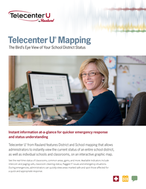
Telecenter U Mapping
A Bird's Eye View of Your School District Status
Telecenter® U Mapping software allows administrators to easily view and interact with the schools and buildings in their district. Utilizing a familiar graphic map interface, the system provides real-time status updates regarding crises situations and day-to-day facility operations – from a bird’s eye district overview, all the way down to each specific school and classroom.
View by District
The high-level map displays every school in an administrator’s district. Simply click each marker to view the status of each school.View by School
Upon clicking a school’s marker, administrators are given a high-level overview of the facility’s floorplan. Selecting a classroom or zone will share metrics such as the room name, extension number, cleaning status, emergencies/check-in status and more.Monitor Developing Situations
Should a classroom make an emergency call to the front office, the room will illuminate in bright red to proactively flag developing situations to administrators.Mitigate and Take Action
During an emergency, a thick red border will highlight the area so administrators and first responders can instantly see which areas and classrooms are affected and focus response efforts appropriately.Telecenter U makes it easier for schools to operate in today’s challenging environment, helping keep school districts, schools and classrooms safe and healthy. By integrating the power of Telecenter U’s infrastructure with a highly visual depiction, administrators are better equipped to engage with and react to the needs of schools within their districts.